Covington, Kentucky
| Covington, Kentucky | |
|---|---|
| — City — | |
 |
|
 |
|
| Coordinates: | |
| Country | United States |
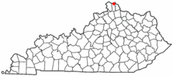
| State | Kentucky |
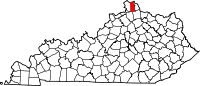
| County | Kenton |
| Founded | 1815 |
| Government | |
| - Type | Council-Manager |
| - Mayor | Denny Bowman (D) |
| Area | |
| - Total | 13.7 sq mi (35.4 km2) |
| - Land | 13.1 sq mi (34.0 km2) |
| - Water | 0.5 sq mi (1.4 km2) |
| Elevation | 509 ft (155 m) |
| Population (2000) | |
| - Total | 43,370 |
| - Density | 3,301.3/sq mi (1,274.4/km2) |
| Time zone | EST (UTC-5) |
| - Summer (DST) | EDT (UTC-4) |
| ZIP code | 41011-41012, 41014-41019 |
| Area code(s) | 859 |
| FIPS code | 21-17848 |
| GNIS feature ID | 0490167 |
| Website | www.covingtonky.gov |
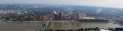
Covington is a city in Kenton County, Kentucky, United States. As of the 2000 census, the city population was 43,370; it is the fifth-most-populous city in Kentucky.[1] It is one of two county seats of Kenton County.[2] Covington is located at the confluence of the Ohio and Licking Rivers. Covington is part of the Cincinnati – Northern Kentucky metropolitan area and is separated from Cincinnati by the Ohio River and from Newport by the Licking River. Covington is located within the Upland South region of the United States of America.
Contents |
History
Covington was established in 1814 when John Gano, Richard Gano, and Thomas Carneal purchased 150 acres (0.6 km2) on the west side of the Licking River at its confluence with the Ohio River, referred to as "the Point," from Thomas Kennedy for $50,000. The city was incorporated by the Kentucky General Assembly a year later. Covington experienced growth during most of the 19th century, only to decline during the Great Depression and the middle 20th century. The city has seen some redevelopment during the late 20th and early 21st centuries.
Geography
Covington is located at (39.065111, -84.509594)[3].
According to the United States Census Bureau, the city has a total area of 13.7 square miles (35.4 km2), of which, 13.1 square miles (34.0 km2) of it is land and 0.5 square miles (1.4 km2) of it (3.88%) is water.
Climate
Covington is located within a climatic transition zone; it is nestled within the southern end of the humid continental climate zone and the northern periphery of the Humid subtropical climate of the Upland South, with hot, humid summers and cool winters. Evidence of both a humid subtropical climate and a humid continental climate can be found here, particularly noticeable by the presence of plants indicative of each climatic region; for example, the Southern magnolia (Magnolia grandiflora) from the subtropics and the Blue spruce from cooler regions are successful landscape plants in and around Covington, Kentucky. The occasional wall lizard and five-lined skink may also be observed scurrying along a rock wall lending a bit of subtropical ambiance to the area.
| Climate data for Covington, Kentucky | |||||||||||||
|---|---|---|---|---|---|---|---|---|---|---|---|---|---|
| Month | Jan | Feb | Mar | Apr | May | Jun | Jul | Aug | Sep | Oct | Nov | Dec | Year |
| Record high °F (°C) | 77 (25) |
77 (25) |
88 (31.1) |
90 (32.2) |
95 (35) |
102 (38.9) |
108 (42.2) |
103 (39.4) |
101 (38.3) |
92 (33.3) |
83 (28.3) |
75 (23.9) |
108 (42.2) |
| Average high °F (°C) | 38 (3.3) |
44 (6.7) |
55 (12.8) |
66 (18.9) |
75 (23.9) |
83 (28.3) |
87 (30.6) |
86 (30) |
79 (26.1) |
67 (19.4) |
54 (12.2) |
43 (6.1) |
64.8 (18.22) |
| Average low °F (°C) | 23 (-5) |
27 (-2.8) |
35 (1.7) |
43 (6.1) |
54 (12.2) |
62 (16.7) |
67 (19.4) |
65 (18.3) |
58 (14.4) |
46 (7.8) |
37 (2.8) |
27 (-2.8) |
45.3 (7.39) |
| Record low °F (°C) | -16 (-26.7) |
-9 (-22.8) |
3 (-16.1) |
18 (-7.8) |
28 (-2.2) |
40 (4.4) |
48 (8.9) |
44 (6.7) |
32 (0) |
20 (-6.7) |
1 (-17.2) |
-13 (-25) |
-16 (-26.7) |
| Precipitation inches (mm) | 2.70 (68.6) |
2.30 (58.4) |
3.49 (88.6) |
3.81 (96.8) |
4.50 (114.3) |
3.71 (94.2) |
3.25 (82.6) |
3.46 (87.9) |
3.04 (77.2) |
2.80 (71.1) |
3.49 (88.6) |
3.02 (76.7) |
39.57 (1,005.1) |
| Source: The Weather Channel.[4] | |||||||||||||
Demographics
| Historical populations | |||
|---|---|---|---|
| Census | Pop. | %± | |
| 1830 | 743 |
|
|
| 1840 | 2,026 | 172.7% | |
| 1850 | 9,408 | 364.4% | |
| 1860 | 16,471 | 75.1% | |
| 1870 | 24,505 | 48.8% | |
| 1880 | 29,720 | 21.3% | |
| 1890 | 37,371 | 25.7% | |
| 1900 | 42,938 | 14.9% | |
| 1910 | 53,270 | 24.1% | |
| 1920 | 57,121 | 7.2% | |
| 1930 | 65,252 | 14.2% | |
| 1940 | 62,018 | −5.0% | |
| 1950 | 64,452 | 3.9% | |
| 1960 | 60,376 | −6.3% | |
| 1970 | 52,535 | −13.0% | |
| 1980 | 49,585 | −5.6% | |
| 1990 | 43,264 | −12.7% | |
| 2000 | 43,370 | 0.2% | |
| Est. 2009 | 43,082 | [5] | −0.7% |
| U.S. Census Bureau[6] | |||
As of the census[7] of 2000, there were 43,370 people, 18,257 households, and 10,132 families residing in the city. The population density was 3,301.3 people per square mile (1,274.4/km²). There were 20,448 housing units at an average density of 1,556.5/sq mi (600.8/km²). The racial makeup of the city was 87.05% White, 10.14% African American, 0.24% Native American, 0.34% Asian, 0.03% Pacific Islander, 0.63% from other races, and 1.57% from two or more races. Hispanics or Latinos of any race were 1.38% of the population.
There were 18,257 households out of which 28.8% had children under the age of 18 living with them, 34.3% were married couples living together, 16.5% had a female householder with no husband present, and 44.5% were non-families. 36.5% of all households were made up of individuals and 12.0% had someone living alone who was 65 years of age or older. The average household size was 2.31 and the average family size was 3.08.
The age distribution was 25.9% under the age of 18, 10.0% from 18 to 24, 33.3% from 25 to 44, 19.0% from 45 to 64, and 11.9% who were 65 years of age or older. The median age was 33 years. For every 100 females there were 95.9 males. For every 100 females age 18 and over, there were 92.0 males.
The median income for a household in the city was $30,735, and the median income for a family was $38,307. Males had a median income of $31,238 versus $24,487 for females. The per capita income for the city was $16,841. About 15.5% of families and 18.4% of the population were below the poverty line, including 25.0% of those under age 18 and 13.4% of those age 65 or over.
Historic Churches
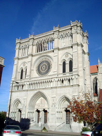
- Cathedral Basilica of the Assumption in Covington
- Holy Cross Roman Catholic Church
- Latonia Christian Church
- Mother of God Parish (Covington, KY)
- Trinity Episcopal Church (Covington, Kentucky)
- Eastside Church of the Nazerine
Notable residents
- Gary Bauer, former Republican presidential hopeful born in Covington in 1946.
- Daniel Carter Beard, his life-size bronze statue, created by sculptor Kenneth Bradford, stands in town.
- Adrian Belew, a musician best known for his role as vocalist and guitarist of King Crimson since the early 1980s, he was born in Covington, December 23, 1949.
- Steve Cauthen, U.S. Racing Hall of Fame jockey born in Covington in 1960 to parents who lived in the community of Walton.
- Bob Charles, Australian politician, member of the Australian House of Representatives.
- Frank Duveneck, realist painter born in Covington on October 9, 1848.
- Mitch English, national television personality best known as one of the hosts on the show The Daily Buzz also featured in theatrical releases and other television programs was born St. Elizabeth Hospital on October 2, 1969
- Henry Forrest (1907–1975), U.S. Racing Hall of Fame Thoroughbred racehorse trainer born in Covington.
- Frederick William Franz, religious leader and theologian 4th president of the Jehovah's Witnesses born in Covington on September 12, 1893.
- Haven Gillespie, songwriter born in Covington, February 6, 1888 and died there on March 14, 1975. He is remembered primarily for "Santa Claus Is Coming to Town".
- Nannie Emory Holding, a Covington native, was a 30-year superintendent and the namesake of the former Holding Institute boarding school in Laredo, Texas.[8]
- David Justice, former Major League Baseball player graduated from Covington Latin School.
- Durward Kirby, actor best-known as the co-host of Candid Camera was born in Covington, August 24, 1912.
- Una Merkel, actress born in Covington December 10, 1903.
- Gertrude Orr, screenwriter born in Covington, January 17, 1891.
- Eddie Peabody, Banjo player died of a stroke at St. Elizabeth Hospital on November 7, 1970; he had collapsed on stage on November 6, 1970 at the Lookout House in Fort Wright, Kentucky.
- Lee Roy Reams, Broadway actor born in Covington, August 23, 1942.
- William Wright Southgate, Northern Kentucky Congressman
- John W. Stevenson Governor and Senator
- Ron Ziegler, White House Press Secretary during U.S. President Richard Nixon's administration, was born in Covington on May 12, 1939.
See also
- List of cities and towns along the Ohio River
- Carneal House
Gallery
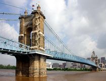 John A. Roebling Suspension Bridge |
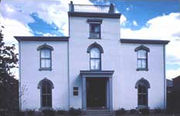
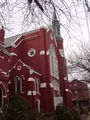
 Historic Trinity Episcopal Church |
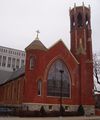
 Historic First United Methodist Church |
References
- ↑ http://travel.ky.gov/facts_populations.aspx
- ↑ "Find a County". National Association of Counties. http://www.naco.org/Template.cfm?Section=Find_a_County&Template=/cffiles/counties/usamap.cfm. Retrieved 2008-01-31.
- ↑ "US Gazetteer files: 2000 and 1990". United States Census Bureau. 2005-05-03. http://www.census.gov/geo/www/gazetteer/gazette.html. Retrieved 2008-01-31.
- ↑ "MONTHLY AVERAGES for Covington, KY". The Weather Channel. http://www.weather.com/weather/wxclimatology/monthly/USKY0801from=month_bottomnav_undeclared. Retrieved 2010-05-26.
- ↑ Annual Estimates of Resident Population for Incorporated Cities in Kentucky: April 1, 2000 to July 1, 2009 United States Census Bureau. Retrieved on 2010-07-07
- ↑ Historical Census Data Retrieved on 2010-05-26
- ↑ "American FactFinder". United States Census Bureau. http://factfinder.census.gov. Retrieved 2008-01-31.
- ↑ "John H. McNeely, "Holding Institute"". The Handbook of Texas. http://www.tshaonline.org/handbook/online/articles/HH/kbh7.html. Retrieved September 30, 2009.
External links
- CovingtonUSA, online newspaper
- Historical Images and Texts of Covington, Kentucky
- Mortimer Murray Benton, First Mayor of Covington, Kentucky
- Oldest House in Covington, Ky. Built 1798
- Garrard Street, circa 1890
- Northern Kentucky Roller Derby
- Railroads of Cincinnati and Northern Kentucky
- Austinburg Neighborhood Association
- South Covington Community Action Association
- Old Seminary Square Neighborhood Association
- A Byrd's Eye View of Covington, Kentucky Photobank
|
||||||||||||||
|
||||||||||||||||||||
|
|||||